Interface class used to access Domain informations.
The domain object is returned by the method Flumy::getDomain.
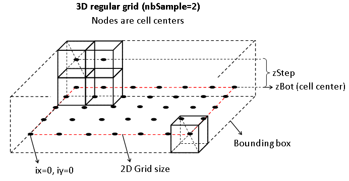
A domain is a geometric 3D grid containing sediment deposited by the channel.
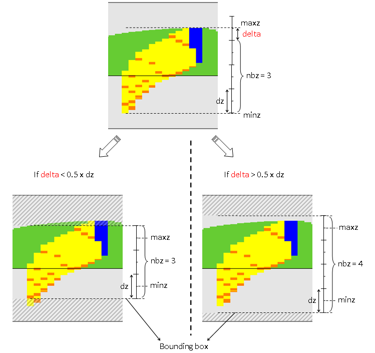
Raw vertical data are not regular (sample thicknesses of deposits can be different).
This is usually called a pillar grid.
The domain grid inherits from 2D grid but have some additional parameters:
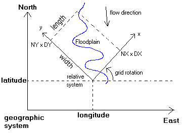
- Flow direction (in degrees - clockwise around vertical axis Oz relative to South-North direction
- Mean slope along flow direction (ratio depth/length) only used to compute velocities and determining new path during avulsions
- Elevation offset at the grid origin along vertical axis Oz (in meters)
- Rotation angle (in degrees - counterclockwise around vertical axis Oz relative to West-East direction)
- Geographical origin coordinates (in meters) (also named grid origin)
The three last parameters are used to locate the domain into a geographical 3D referential system.
The origin of the 2D grid (_ox and _oy members) inherited from GridParams class is ignored (always 0,0).
This class provides some methods used to convert 2D points coordinates into the following referential systems:
- geographical: coordinates (in meters) correspond to absolute geographic coordinates as shown below (ignoring projection system)
- relative: coordinates (in meters) correspond to relative coordinates as shown below (working system)
- grid: coordinates (0-bases indexes) correspond to node position into the 2D grid
Each domain grid node has a vertical collection of deposition units objects.
This class informs you about the vertical location of the sample stack (bottom, top)
Node sample stack can be read by two ways:
- getIrregular method: returning the irregular vertical collection of deposition units for a grid node
- getRegularPile method: returning the regular vertical collection for a given step (in meters) of facies (integers) for a grid node
The getRegular* methods also permits to retrieve the whole block in one call.
Look at the User Manual for further details about domain geometry.
|
| | iDomain () |
| | Default constructor. More...
|
| |
| virtual | ~iDomain () |
| | Destructor. More...
|
| |
| virtual MP_real | getSlope () const =0 |
| | Return global mean slope along flow direction (ratio positive decreasing) More...
|
| |
| virtual MP_real | getSlopeAlongX () const =0 |
| | Return global mean slope along X (ratio positive decreasing) More...
|
| |
| virtual MP_real | getSlopeAlongY () const =0 |
| | Return global mean slope along Y (ratio positive decreasing) More...
|
| |
| virtual MP_real | getZrefGeo () const =0 |
| | Return grid origin elevation (in meters) More...
|
| |
| virtual MP_real | getRotGridGeo () const =0 |
| | Return grid rotation (in degrees counterclockwise) relative to West-East direction (90° <=> South-North) More...
|
| |
| virtual MP_real | getRotFlowGeo () const =0 |
| | Return flow rotation (in degrees clockwise) relative to South-North direction (90° <=> West-East) More...
|
| |
| virtual Point2D | getOriginGeo () const =0 |
| | Return grid origin into the geographical referential system (in meters) More...
|
| |
| virtual MP_real | getErodMax () const =0 |
| | Return the maximum erodibility coefficient encountered inside the domain. More...
|
| |
| virtual MP_age | getOldestAge () const =0 |
| | Return the age (in number of iteration since the simulation beginning) of the oldest deposit encountered inside the domain. More...
|
| |
| virtual MP_real | getZMaxGeo () const =0 |
| | Return the highest elevation of the domain (in meters) (including elevation at origin but excluding mean slope) More...
|
| |
| virtual MP_real | getZMinGeo () const =0 |
| | Return the lowest elevation of the domain (in meters) (including elevation at origin but excluding mean slope) More...
|
| |
| virtual MP_real | getZMaxRel () const =0 |
| | Return the highest elevation of the domain (in meters) (excluding elevation at origin and mean slope) More...
|
| |
| virtual MP_real | getZMinRel () const =0 |
| | Return the lowest elevation of the domain (in meters) (excluding elevation at origin and mean slope) More...
|
| |
| virtual MP_real | getMeshX () const =0 |
| | Assessor get to protected member variable _dx. More...
|
| |
| virtual MP_real | getMeshY () const =0 |
| | Assessor get to protected member variable _dx. More...
|
| |
| virtual MP_int | getNbNodeX () const =0 |
| | Assessor get to protected member variable _nx. More...
|
| |
| virtual MP_int | getNbNodeY () const =0 |
| | Assessor get to protected member variable _nx. More...
|
| |
| virtual GridParams | getGrid () const =0 |
| | Return domain geometry in grid object. More...
|
| |
| virtual MP_real | getMinTopo (bool with_water_depth=true) const =0 |
| | Return domain min topography (geographic) More...
|
| |
| virtual MP_real | getMaxTopo (bool with_water_depth=true) const =0 |
| | Return domain max topography (geographic) More...
|
| |
| virtual MP_real | getMeanTopo (bool with_water_depth=true) const =0 |
| | Return domain mean topography (geographic) More...
|
| |
| virtual MP_real | getProportionFull (MP_stut fac, MP_real zmin=MP_UNKNOWN_REAL_VALUE, MP_real zmax=MP_UNKNOWN_REAL_VALUE) const =0 |
| | Return facies proportion between min and max geographical elevations. More...
|
| |
| virtual MP_real | getProportion (MP_stut fac, MP_int ix_min, MP_int ix_max, MP_int iy_min, MP_int iy_max, MP_real zmin=MP_UNKNOWN_REAL_VALUE, MP_real zmax=MP_UNKNOWN_REAL_VALUE) const =0 |
| |
| virtual Point2D | getGeoPointFromGrid (const MP_int &ix, const MP_int &iy) const =0 |
| | Return a point into the geographical referential system from a point into the grid referential system. More...
|
| |
| virtual Point2D | getGeoPointFromRel (const Point2D &relPoint) const =0 |
| | Return a point into the geographical referential system from a point into the relative referential system. More...
|
| |
| virtual Point2D | getRelPointFromGeo (const Point2D &geoPoint) const =0 |
| | Return a point into the relative referential system from a point into the geographical referential system. More...
|
| |
| virtual Point2D | getRelPointFromGrid (const MP_int &ix, const MP_int &iy) const =0 |
| | Retrieve relative point from a grid one. More...
|
| |
| virtual Point2D | getGridPointFromRel (const Point2D &relPoint) const =0 |
| | Retrieve grid point from relative one. More...
|
| |
| virtual Point2D | getGridPointFromGeo (const Point2D &geoPoint) const =0 |
| | Retrieve grid point from geographical one. More...
|
| |
| virtual bool | isValid (const MP_int &ix, const MP_int &iy) const =0 |
| | Return true if indices are valid grid indices. More...
|
| |
| virtual RealList | getAllThickness () const =0 |
| | Return all thicknesses / facies / grainsizes and ages. More...
|
| |
| virtual FaciesList | getAllFacies () const =0 |
| |
| virtual RealList | getAllGrainsize () const =0 |
| |
| virtual IntList | getAllGrainsizeClass () const =0 |
| |
| virtual AgeList | getAllAge () const =0 |
| |
| virtual DepositsList | getDeposits (MP_int ix, MP_int iy) const =0 |
| | Retrieve irregular vertical facies collection. More...
|
| |
| virtual bool | getIrregular (MP_int ix, MP_int iy, DepositsList *list) const =0 |
| | Retrieve irregular vertical facies collection. More...
|
| |
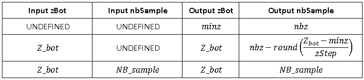
| virtual bool | getRegularPile (MP_int ix, MP_int iy, MP_real zStep, FaciesList *facies, AgeList *ages=NULL, RealList *granulo=NULL, MP_real *zBot=NULL, MP_int *nbSample=NULL) const =0 |
| | Retrieve regular vertical facies collection located at a domain grid node for a given elevation step. More...
|
| |
| virtual bool | getRegular (MP_int ix_min, MP_int ix_max, MP_int iy_min, MP_int iy_max, MP_real zStep, FaciesList *facies, AgeList *ages=NULL, RealList *granulo=NULL, MP_real *zBot=NULL, MP_int *nbSample=NULL) const =0 |
| |
| virtual FaciesList | getRegularFacies (MP_real zStep, MP_real zBot, MP_int nbSample) const =0 |
| |
| virtual RealList | getRegularGrain (MP_real zStep, MP_real zBot, MP_int nbSample) const =0 |
| |
| virtual AgeList | getRegularAge (MP_real zStep, MP_real zBot, MP_int nbSample) const =0 |
| |
| virtual bool | getTopo (Topo &topo, bool with_water=true, MP_age age_limit=MP_UNKNOWN_INT_VALUE) const =0 |
| | Retrieve current topography in geographical system (including grid elevation) More...
|
| |
| virtual bool | saveF2G (const MP_string &filename, MP_real dz, bool save_facies, bool save_grain, bool save_age, MP_real min_z=MP_UNKNOWN_REAL_VALUE, MP_real max_z=MP_UNKNOWN_REAL_VALUE, const MP_string &order=MP_DEFAULT_CELLS_ORDER) const =0 |
| |
| virtual std::vector< WellStat > | getCondStats () const =0 |
| |
| virtual bool | getCenterlineDisc (CenterlineDisc &cldisc, const iChannel *ch) const =0 |
| |